
Aotearoa New Zealand · A visual record
New Zealand
Flood Photo Gallery
Explore New Zealand flood photographs by region and event, from historic floods to more recent emergencies. Discover the context, image credits and regional information behind each collection.
14 photographs · 9 event collections · 8 regions1975 →
2026
Historical images. Present-day learning.
A growing, curated collection — not a complete archive, flood-risk map or live warning service.
Use current council flood maps and Civil Defence advice. Never enter a flooded area to take photographs.
Browse the collection
Find a region. Explore an event.
Each record includes an event date, a photograph date where known, a source credit and a confirmed reuse licence. Images can show damage or aftermath, as well as floodwater.
Showing 9 event records.
No photograph in this collection matches those filters yet. This does not mean the region has no flood history. Use its regional information link below.

Photograph: 16 February 2023. An emergency-response vehicle is shown; this is not advice to drive through floodwater.
PLTOFF Callum Post, Ohakea Photo / New Zealand Defence Force. Crown Copyright 2023. Image record · CC BY 4.0. Display resized only; no SSFP crop or retouch. Licence checked 26 September 2026. No endorsement of SSFP is implied.
Hawke’s Bay · 2023
Cyclone Gabrielle: access, damage and response
Cyclone Gabrielle · February 2023
Three NZDF photographs document flooded roads near Puketapu, the Esk River railway bridge and the helicopter supply response for an isolated community. They show different places and stages of the response, not a before-and-after sequence.
A flood plan needs to consider access and essential supplies as well as the building itself.

Photograph: 23 February 2023. The source identifies the view as looking downstream from the highway.
SGT Vanessa Parker / New Zealand Defence Force. Crown Copyright 2023. Image record · CC BY 4.0. Display resized only; no SSFP crop or retouch. Licence checked 26 September 2026. No endorsement of SSFP is implied.

Photograph: 18 February 2023. The source caption describes supplies for Aropaoanui; this image documents the response, rather than a flood-depth measurement.
New Zealand Defence Force. Crown Copyright 2023. Image record · CC BY 4.0. Display resized only; no SSFP crop or retouch. Licence checked 26 September 2026. No endorsement of SSFP is implied.

Photograph: 20 April 2026.
Alan Tennyson, own photograph, via Wikimedia Commons. Image record · CC BY-SA 4.0. Display resized only; no SSFP crop or retouch. Licence checked 26 September 2026. No endorsement of SSFP is implied.
Wellington · 2026
After the flood: Wellington’s clean-up
Wellington flooding · April 2026
These photographs record flood aftermath on 20 April and clean-up on Lincoln Street on 21 April. They document recovery rather than the flood peak, and should not be read as a complete map of affected areas.
The effects of flooding continue after the water recedes. Follow official advice before returning to affected areas.

Photograph: 21 April 2026.
Alan Tennyson, own photograph, via Wikimedia Commons. Image record · CC BY-SA 4.0. Display resized only; no SSFP crop or retouch. Licence checked 26 September 2026. No endorsement of SSFP is implied.

Photograph: 26 June 2021. Photographed downstream of the SH77 bridge, west of the campground, after the flood event.
Lord A.Nelson, own photograph, via Wikimedia Commons. Image record · CC BY-SA 4.0. Display resized only; no SSFP crop or retouch. Licence checked 26 September 2026. No endorsement of SSFP is implied.
Canterbury · 2021
A river landscape after the flood
Canterbury flooding · May–June 2021
This photograph records the Selwyn River at Glentunnel after the May–June floods. Taken on 26 June, it shows the river corridor downstream of the SH77 bridge rather than conditions at the flood peak.
A photograph taken later can reveal a different part of the story. Always check the capture date as well as the event date.

Photograph: 1975; exact capture day not confirmed. The source identifies the event as 1975. Later digital-file dates are not treated as the flood date.
Phillip Capper, via Flickr and Wikimedia Commons. Image record · CC BY 2.0. Display resized only; no SSFP crop or retouch. Licence checked 26 September 2026. No endorsement of SSFP is implied.
West Coast · 1975
A rescue on the Inangahua
Inangahua flood · 1975
Phillip Capper’s historical photograph records a rescue during the 1975 Inangahua flood. The exact day is not confirmed in the source; the later digital-file date is kept separate from the event year.
Historical records help communities remember the human impact of flooding. Current local advice remains the guide for today’s decisions.
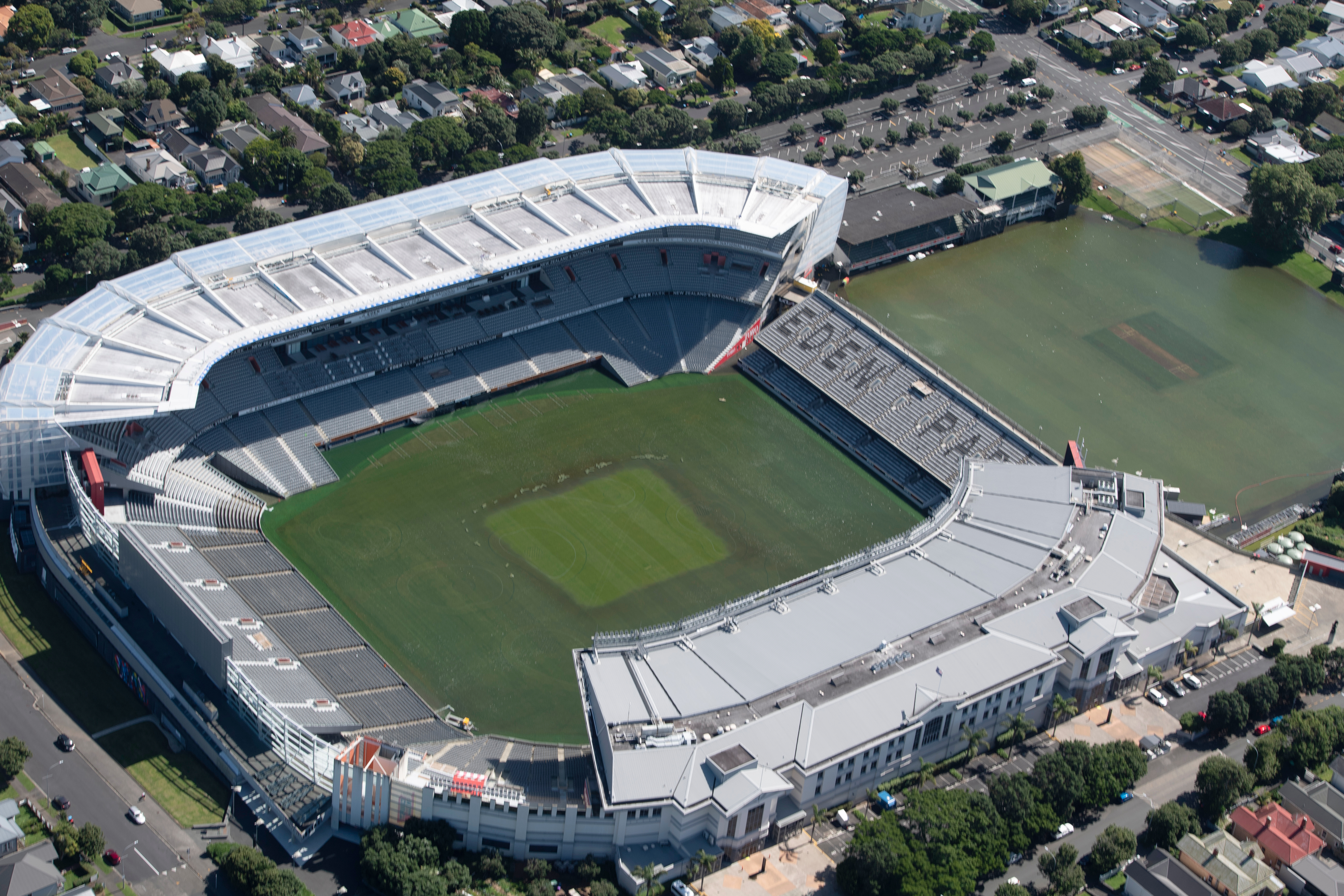
Auckland · 2023
Eden Park, seen from above
Auckland flooding · January–February 2023
Photograph: 1 February 2023 (file metadata)
Flooding across Auckland brought evacuations, road disruption and an emergency response. NZDF personnel supported evacuation and welfare work. This photograph is part of the documented response period; it is not presented as a photograph of the 27 January flood peak.
A familiar urban place can become part of a much wider emergency. Plan safe routes and alternatives before roads are affected.
NZ Defence Force: Auckland flood response →
Explore Auckland flood information
Photo source & reuse details
The initial upload description used 28 January; current file metadata and summary say 1 February. The photo date is labelled as metadata, separate from the event period. Reuse record checked 25 September 2026. Photographer and source organisations do not endorse SSFP. Read the full source record.

Glen Eden · 15 February 2023. The source identifies this as the aftermath of the North Island floods and Cyclone Gabrielle, not the flood peak.
Prosperosity, via Wikimedia Commons. Image record · CC BY 4.0. Display resized only; no crop or retouch. Licence checked 25 September 2026. No photographer endorsement of SSFP is implied.

Pukekawa / Auckland Domain · 30 January 2023. The photographer records the stream draining floodwaters during the North Island floods.
Spil030, via Wikimedia Commons. Image record · CC BY-SA 4.0. Display resized only; no crop or retouch. Licence checked 25 September 2026. No photographer endorsement of SSFP is implied.

Canterbury · 2019
When a river leaves its channel
Rangitata / Rakitata flooding · December 2019
Photograph: 8 December 2019
Environment Canterbury records the river breaking out of its main channel during the December 2019 event, damaging roads, rail, farms, electricity infrastructure and flood-protection works.
Flood effects extend beyond an individual building. Consider how transport, electricity and access might be interrupted.
Environment Canterbury: flood-event context →
Explore Canterbury flood information
Photo source & reuse details
CC BY 4.0 chosen from the file’s dual licence; photograph displayed without cropping or retouching. Reuse record checked 25 September 2026. Photographer and source organisations do not endorse SSFP. Read the full source record.

Otago · 1995
A record of the Clutha flood
Clutha / Mata-Au flooding · December 1995
Photograph: 14 December 1995; archive digitisation later
Archives New Zealand records heavy rain and snowmelt contributing to the December 1995 South Island floods. The Clutha flood peaked on 14 December, affecting low-lying areas of Alexandra and transport routes.
Flooding can arrive from rainfall well upstream. Local river information matters even when the weather at your home looks different.
Archives New Zealand: original archive record →
Explore Otago flood information
Photo source & reuse details
1995 is the photograph/event year. The 2015 date on the digital record is not the flood date. Source composite retained, uncropped; displayed under CC BY-SA 2.0. Reuse record checked 25 September 2026. Photographer and source organisations do not endorse SSFP. Read the full source record.

Southland · 1984
Tuatapere’s flooded homes
Southland floods · January 1984
Photograph: 27 January 1984
The January 1984 floods led to emergencies and evacuations in Invercargill, Ōtautau and Tuatapere. Environment Southland describes the event as a catalyst for major flood-protection construction and upgrades.
Community protection and household planning work together. Historical photographs help explain why flood plans need to be maintained.
Environment Southland: 40-year retrospective →
Explore Southland flood information
Photo source & reuse details
Commons specifies Lindsay Faulkner/CWArchives attribution and CC BY 4.0; links to the holding archive’s Tuatapere record. Reuse record checked 25 September 2026. Photographer and source organisations do not endorse SSFP. Read the full source record.

Waikato · 1981
A township changed by flooding
Waikino flood · 1981
Photograph: 1981; exact photograph day not confirmed
This photograph records damage at Waikino during the 1981 flood. Waikato Regional Council identifies the 1981 flooding as a major driver behind the modern Waihou Valley flood-protection scheme.
Past events help communities understand risk. Use current council information when making decisions about a particular property.
Waikato Regional Council: scheme history →
Explore Waikato flood information
Photo source & reuse details
Photographer attribution explicitly required. Commons’ current source file had a watermark removed in 2010; SSFP makes no additional crop or retouch. Exact capture date unavailable. Reuse record checked 25 September 2026. Photographer and source organisations do not endorse SSFP. Read the full source record.
The bigger picture
Flood information for all 16 regions
Our photo collection is still growing. Find local sources, flood history and preparation information for your region.
About this collection
Where do the photographs come from?
This collection uses files with verified Creative Commons reuse licences, including records from Archives New Zealand and NZDF. The source, photographer and licence are shown beside each image. Images are displayed at a web-friendly size without SSFP cropping or retouching. They are not SSFP installations or evidence of product performance.
Why are some regions and events missing?
We only add a photograph once its rights, location and context can be checked. Absence from this collection says nothing about local flood risk. This version includes Auckland, Waikato, Hawke’s Bay, Wellington, West Coast, Canterbury, Otago and Southland; other regions link to their information pages.
Can I suggest a photograph?
Adults and organisations can contact SSFP with a source link or a photograph they own. We need the photographer, place, date and written publication permission or a suitable licence before using it. Please do not send private addresses, identifiable children or sensitive material without appropriate permission. Nothing is published automatically.
Can schools use the gallery?
Yes. Discuss what a photograph shows, what it cannot tell us and how communities prepare. For younger children, use the Kids Flood Zone. If downloading or republishing an image, follow its individual licence and keep the required credit.